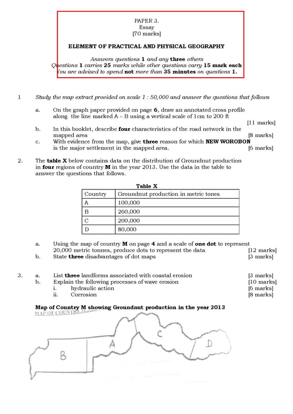
ELEMENT OF PRACTICAL AND PHYSICAL GEOGRAPHY Answers Questions 1 carries 25 You are advised to 1 Study the map extract provided on scale 1 a. On the graph paper provided on page along the line marked A b. In this booklet, describe mapped area c. With evidence from the map, give is the major settlement in the mapped area. 2. The table X below contains in four regions of country M answer the questions that follows. Country A B C D a . Using the map of country 20,000 metric tonnes, produce dots to represent the data b . State three disadvantages of dot maps 3. a. List three landform s b. Explain the following processes of wave erosion i. hydraulic action ii. Corrosion Map of Country M showing Groundnut production in the PAPER 3 . Essay [ 7 0 marks] ELEMENT OF PRACTICAL AND PHYSICAL GEOGRAPHY Answers questions 1 and any three others 25 marks while other questions carry 15 spend not more than 35 minutes on questions Study the map extract provided on scale 1 : 50,000 and answer the questions that follows On the graph paper provided on page 6 , draw an annotated cross profile the line marked A – B using a vertical scale of 1cm to 200 ft this booklet, describe four characteristics of the road network in the With evidence from the map, give three reason for which NEW is the major settlement in the mapped area. contains data on the distribution of Groundnut production M in the year 2013. Use the data in the table to answer the questions that follows. Table X Country Groundnut production in metric tones 100,000 260,000 200,000 80,000 Using the map of country M on page 4 and a scale of one dot 20,000 metric tonnes, produce dots to represent the data disadvantages of dot maps s associated with coastal erosion Explain the following processes of wave erosion hydraulic action Map of Country M showing Groundnut production in the year 201 ELEMENT OF PRACTICAL AND PHYSICAL GEOGRAPHY mark each questions 1 . 50,000 and answer the questions that follows , draw an annotated cross profile B using a vertical scale of 1cm to 200 ft [11 marks] characteristics of the road network in the [8 marks] NEW WOROBON [ 6 marks] of Groundnut production in the year 2013. Use the data in the table to Groundnut production in metric tones dot to represent [ 12 marks] [ 3 marks] [ 3 marks] [10 marks] [6 marks] [8 marks] year 201 3
 Map Reading in Geography WAEC Questions Page 6 Page 8